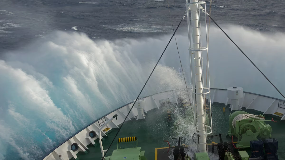
The Drake Passage is the roughly 800-kilometer (500-mile) stretch of open ocean separating Cape Horn, at the southern tip of South America, from the South Shetland Islands near the Antarctic Peninsula. It is the shortest sea route between Antarctica and any other landmass, which is why nearly every ship-based Antarctic expedition sails through it. The passage also marks the narrowest constriction point of the Antarctic Circumpolar Current, the largest ocean current on Earth, making this stretch of water as scientifically significant as it is geographically dramatic.
For travelers, crossing this stretch of ocean is the price of admission to Antarctica: roughly two days of open-water sailing that can shift from glassy calm to steep swells within hours. This guide covers the geography, history, climate role, seasonal patterns, wildlife, and practical planning behind a Drake Passage crossing.
Where Is the Drake Passage Located
The Drake Passage sits between Cape Horn (55°S), the southernmost point of South America, and the South Shetland Islands (around 62–63°S), roughly 100 miles (160 km) north of the Antarctic Peninsula. It connects the southwestern Atlantic Ocean, specifically the Scotia Sea, with the southeastern Pacific Ocean, forming part of the broader Southern Ocean that encircles Antarctica.
Width estimates vary by source and reference point, ranging from about 500 miles (800 km) at the narrowest constriction to 600 miles (1,000 km) at the broadest crossing points. The seafloor here is a genuine deep-ocean gateway rather than a shallow shelf, with depths typically between 3,000 and 4,800 meters, and some basins approaching 6,000 meters.
Departure ports on the South American side are Ushuaia, Argentina, and, for fly-cruise itineraries, Punta Arenas, Chile. On the Antarctic side, ships typically make first landfall at the South Shetland Islands, with King George Island serving as the main hub for both scientific research stations and fly-cruise arrivals.
The Polar Front and Scotia Sea
Within the passage lies the Antarctic Polar Front (also called the Antarctic Convergence), the boundary where cold, dense Antarctic surface water meets warmer subantarctic water. This front creates a sharp shift in temperature and salinity and concentrates nutrients that support a rich marine food web along the crossing route. On the Atlantic side, the water opens into the Scotia Sea, a biologically productive basin bounded by the South Georgia and South Orkney island arcs.
Read more: Drake Passage
Why This Gateway Matters for Global Climate
This gateway did not always exist. Geological and isotopic evidence indicates it opened roughly 30 million years ago as South America and Antarctica drifted apart, an event tied to the onset of the modern Antarctic Circumpolar Current and a major cooling of the Antarctic continent. Before that separation, warmer water could not circulate freely around the pole, and Antarctica held a much smaller ice sheet.
Because no landmass interrupts the flow at this latitude, the Antarctic Circumpolar Current moves an immense volume of water eastward around the continent continuously. Monitoring here has recorded average transport of approximately 125 Sverdrups (one Sverdrup equals one million cubic meters of water per second), with variation between roughly 95 and 158 Sverdrups depending on conditions; some estimates put peak transport as high as 170 million cubic meters per second.
This transport links the Atlantic, Pacific, and Indian Oceans into a single connected system. Oceanographers describe the return flow of cold water northward through this corridor as part of the “cold water route,” a process that directly influences the strength of the Atlantic meridional overturning circulation and, by extension, global heat distribution. Because it is the current’s narrowest chokepoint, this location is one of the primary sites scientists use to measure circumpolar transport and validate global ocean and climate models. Long-term monitoring here also feeds directly into research on the Southern Ocean’s role in the global carbon cycle, since this water mass exchanges heat and carbon dioxide with the atmosphere across enormous distances.
The History Behind the Name
Despite its name, Sir Francis Drake never actually sailed through these waters. In 1578, during his circumnavigation of the globe, a storm blew his ship far south of the Strait of Magellan, revealing that South America was not connected to a larger unknown southern continent — but Drake himself continued through the known route of the Strait of Magellan rather than the open water to the south. Spanish navigator Francisco de Hoces is believed to have sighted the same waters even earlier, in 1525, after being blown off course near the Strait of Magellan, which is why Spanish-language sources still refer to it as the Mar de Hoces.
The first confirmed transit came decades later, in 1616, when Dutch navigators Willem Schouten and Jacob Le Maire sailed through while seeking an alternative trade route around Spanish-controlled Magellan Strait. English-language cartography later attached Drake’s name to the route, and it became the standard international reference by the 19th century.
How Rough Is the Drake Passage, Really
Rough seas here result from straightforward physics: strong, unobstructed westerly winds drive the Antarctic Circumpolar Current through a narrow gap, and the interaction between wind and current generates powerful swells. With no landmass at this latitude to dissipate storm energy, weather systems can build across thousands of kilometers of open Southern Ocean before funneling directly into the strait. This unbroken wind belt spans what sailors have long called the Roaring Forties, Furious Fifties, and Screaming Sixties — successive latitude bands of increasingly strong prevailing westerlies that a ship must cross en route to Antarctica.
Drake Shake vs. Drake Lake
| Factor | Drake Lake | Drake Shake |
| Typical wave height | 1–4 meters | 5–15 meters |
| Approximate frequency | Roughly 65–70% of crossings | Roughly 25–30% of crossings |
| Onboard experience | Steady sailing, full outdoor deck access | Significant pitching and rolling; most passengers stay below deck |
| Seasickness risk | Low to moderate | High, even for experienced sailors |
| Photography conditions | Stable footing, easier wildlife shots | Difficult; spray and motion limit deck time |
Mean wave heights across all crossings average around 4–5 meters, while a severe Drake Shake can produce waves of 12–15 meters (40–50 feet). Which experience you get is essentially a matter of timing rather than season — a ship can encounter a Drake Lake in December and a Drake Shake in January on back-to-back voyages, since conditions depend on the position of active storm systems rather than the calendar.
How It Compares to Other Rough Seas
Sailors and cruise researchers consistently rank this route above other notoriously rough waters, including the Bay of Biscay off France and Spain and winter crossings of the North Atlantic. The distinction comes down to geography: the Bay of Biscay and North Atlantic are bordered by continental shelves and landmasses that eventually break up swell energy, and both calm considerably in summer. This latitude band has no such buffer at any time of year, because it sits at the one place on Earth where ocean water can circle the globe without touching land.
| Crossing | Typical wave height | Seasonal relief | Landmass buffering |
| Drake Passage | 4–5 m average, up to 15 m | None — rough conditions possible year-round | None |
| Bay of Biscay | Moderate, occasionally severe in storms | Calmer in summer | Partial, from surrounding coastline |
| North Atlantic (winter) | Moderate to severe | Calmer in summer | Partial, from continental shelves |
Best Time to Cross
Antarctic expedition season runs from roughly November through March, the only window when the Southern Ocean route is navigable and Antarctic wildlife is most active. Each month offers a different balance of daylight, ice, and wildlife, though sea conditions themselves remain unpredictable throughout.
- November: Longer daylight returns; pack ice is often still extensive near the Peninsula, limiting some landing sites but rewarding visitors with pristine snow and active penguin courtship behavior.
- December–January: Peak season, with the longest daylight hours of the year and penguin chicks hatching; ship traffic and demand are highest.
- February: Increased whale sightings as krill populations peak; landing sites are less snow-covered, revealing more rock and wildlife activity.
- March: Late season brings dramatic sunsets, fewer crowds, and strong whale activity, though daylight hours shorten and storm frequency can increase.
No month guarantees calmer seas — conditions depend on real-time low-pressure systems rather than the calendar, so preparation matters more than timing your booking around a “safer” month.
How Forecasts Are Made — and Why They Change Fast
Weather forecasting for this route relies on tracking low-pressure systems that form and travel across the open Southern Ocean, an area with far fewer weather stations and ship reports than more traveled shipping lanes. Expedition captains use satellite imagery, buoy data, and wind and wave models to plan departure timing and route adjustments, sometimes altering course to minimize exposure to the worst part of an approaching system.
Because storm systems in this latitude band move quickly and the observation network is comparatively sparse, forecasts issued more than two to three days out carry meaningful uncertainty. Forecast confidence genuinely narrows only in the final 24–48 hours before departure, which is why experienced crews often cannot say whether a given voyage will be smooth or rough until it’s already underway.
Planning an Antarctic Trip
Most Antarctic Peninsula voyages depart from Ushuaia, Argentina, the southernmost city in the world, and follow a standard structure: roughly two days crossing outbound, several days exploring the Peninsula and South Shetland Islands, then two days crossing back — typically a 10–11 day itinerary in total.
Departure Ports and Ship Types
Expedition ships range widely in size and passenger capacity, which affects both the crossing experience and the shore-landing experience once in Antarctica:
- Small expedition ships (roughly 100–200 passengers): Better landing flexibility under IAATO rules, more intimate wildlife viewing, but generally more perceptible motion in rough conditions.
- Mid-size expedition ships (200–300 passengers): A balance of stability and landing access, with modern stabilizer systems that reduce rolling.
- Larger vessels (300+ passengers): Typically smoother in rough seas due to size and stabilizers, but the International Association of Antarctica Tour Operators (IAATO) limits landings to 100 passengers ashore at a time, so larger ships may offer fewer or shorter landing opportunities per guest.
Fly-Cruise vs. Traditional Cruise
| Factor | Traditional Ship Crossing | Fly-Cruise |
| Departure point | Ushuaia, Argentina | Punta Arenas, Chile, with a flight to King George Island |
| Time to Antarctica | Roughly 36–48 hours each way | Roughly 2 hours by air |
| Sea exposure | Full exposure, both directions | Skipped entirely, or on one direction for hybrid itineraries |
| Weather dependency | High, though ships can reroute around storms | Very high — flights are frequently delayed or canceled by weather |
| Relative cost | Lower | Higher |
| Total trip length | Longer, with sea days built in | Shorter, with more days spent ashore in Antarctica |
Fly-cruise itineraries suit travelers most concerned about seasickness or with limited vacation time, but the trade-off is dependency on small-aircraft operations that are themselves highly weather-sensitive and prone to delay.
Booking Considerations
- Book cabins closer to the ship’s center and lower decks for reduced motion in rough conditions.
- Confirm whether the operator is an IAATO member, since IAATO sets the passenger-landing limits and environmental protocols governing nearly all Antarctic tourism.
- Ask how the operator handles missed or shortened landings and whether the itinerary includes contingency routing for storm avoidance.
Wildlife Along the Route
The crossing itself is a wildlife-viewing opportunity, since the Polar Front and converging currents concentrate marine life along the way.
Birds: Wandering and black-browed albatrosses are frequently seen gliding for long stretches with minimal wingbeats, using dynamic soaring to exploit wind gradients just above the wave surface. Cape petrels, giant petrels, and various prion species also follow ships, drawn by consistent winds and disturbed food near the surface.
Marine mammals: Humpback and fin whales are commonly sighted, particularly near the Polar Front, and southern right whales occasionally appear in the same waters. Killer whales are less common but have been documented in the area. Elephant seals and fur seals are more typically seen near the South Shetland Islands and Peninsula coastline rather than mid-crossing, but sightings from the ship increase as it approaches land.
Photography tips: Deck time during calmer stretches offers the steadiest shooting conditions; a fast shutter speed helps freeze albatross wing motion, and image stabilization compensates for ship movement. Early morning and late evening light during peak season provides the longest usable golden-hour windows.
Is It Dangerous?
This route has a long history of shipwrecks from the age of sail, when vessels lacked modern stabilization, satellite forecasting, and rescue capability. Modern expedition ships are purpose-built for Southern Ocean conditions, carry certified ice-class hulls, and operate under strict IAATO and international maritime safety protocols, which has made passenger crossings dramatically safer than historical transits. Serious injuries and fatalities on modern tourist voyages are rare, though the severe weather potential means seasickness, minor injuries from falls, and occasional itinerary disruptions remain realistic possibilities on any given trip.
Frequently Asked Questions
How wide is the Drake Passage exactly?
Estimates range from about 500 miles (800 km) at the narrowest constriction to roughly 600 miles (1,000 km) at broader crossing points, depending on the exact reference locations used.
Is this the roughest sea in the world?
It is widely regarded as one of the roughest routinely traveled ocean crossings, largely because no landmass at that latitude interrupts wind or wave energy. Other notorious waters like the Bay of Biscay and winter North Atlantic can be severe but generally calm seasonally, while this route has no reliable calm season.
Has anyone died crossing the Drake Passage?
It has a documented history of shipwrecks and fatalities dating back centuries, particularly during the age of sail. Modern expedition vessels, satellite forecasting, and IAATO safety protocols have made passenger crossings far safer, and serious incidents on modern tourist voyages are uncommon.
Can children safely make the crossing?
Many operators allow children on Antarctic voyages, though minimum age policies vary by cruise line, and some restrict landings or specific activities for younger passengers. Given the unpredictable motion, families should check operator-specific age policies and seasickness preparedness before booking.
What happens if I get seasick during the crossing?
Most expedition ships carry onboard medical staff and seasickness medication, and cabins are stocked with sickness bags as a standard precaution. Staying on deck with a fixed horizon view, taking medication preemptively, and choosing a lower, more central cabin all reduce symptoms for most travelers.
Can ships cancel or reroute the crossing?
Yes. Captains can adjust timing, speed, or heading to avoid the worst part of an approaching storm system, and in rare cases itineraries are shortened or landings skipped for safety. Complete cancellation is uncommon, since it is the primary route to the Peninsula, but schedule changes are routine.
Is Wi-Fi available onboard?
Most modern expedition ships offer satellite Wi-Fi, though connection speed and reliability at these latitudes are typically limited compared to coastal or port-based connectivity, and rough seas can further disrupt satellite signal stability.
Do luxury or larger ships feel smoother than smaller vessels?
Generally, larger ships with advanced stabilizer systems produce less perceptible motion than smaller expedition vessels, though no ship is immune to severe conditions. The trade-off is that larger ships are subject to IAATO’s 100-person landing limit, which can mean fewer shore excursions per passenger.
How many ships make the crossing each Antarctic season?
Antarctic tourism has grown substantially in recent years, with IAATO-member vessels making hundreds of voyages each November-to-March season; exact annual figures vary year to year based on fleet capacity and demand.
Can I avoid the sea crossing entirely to reach Antarctica?
Yes. Fly-cruise itineraries fly passengers from Punta Arenas, Chile, directly to King George Island, boarding the ship there and skipping one or both sea crossings, though flights depend on weather and typically cost more than a standard ship-only voyage.